
3D Modelling
elipptic drone to capture images of the telecom tower from all angles autonomously and collect high-resolution photos sent to the central server for image acquisition. elippticEngine photogrammetry software to stitch together the collected images and analyse the overlapping features to create a 3D point cloud. This point cloud represents the tower’s shape and structure. Our software applies algorithms to improve the accuracy and quality of the point cloud. The next step is creating a surface representing the telecom tower’s exact shape and structure. The last step is texture mapping, in which our software applies the collected drone images onto the 3D mesh to create a realistic texture for the model. This step provides visual details such as colours and textures resembling the telecom tower.
 Benefits
The photogrammetric process can accurately recreate a 3D model of a telecom tower, providing valuable insights and data for various purposes like maintenance, analysis, or planning.

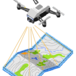
2.5D Mapping
elipptic drones can create 2.5D mapping using images by capturing aerial photographs from different viewpoints. These images are then processed using elippticEngine software that uses photogrammetry algorithms to reconstruct the three-dimensional structure of the area being mapped. Our software can analyse the visual information, such as the position and orientation of features in each image, to calculate the distance and height of objects on the ground. This data is then used to create a digital elevation model (DEM) or a terrain surface. The output of this process is a 2.5D map, which represents the area’s topography with accurate elevation information.
 Benefits
2.5D mapping can be useful in various applications, including urban planning, land surveying, agriculture, and environmental monitoring, as it provides valuable insights into the terrain and allows for accurate measurements and analysis.

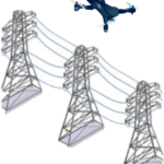
Power Lines Continuity
elipptic drones can be used to check power lines’ continuity by visually inspecting the power lines from an aerial perspective. The drone is flown along the power lines, capturing video footage of the entire transmission network, which is sent to the central server to be checked by elippticEngine for any signs of damage or discontinuity and widely seen factors such as missing or broken insulators, leaning or sagging poles, vegetation encroachment, or any other issues that could disrupt the continuity of the power lines. Based on the video analysis findings, a report highlights the state of the power lines and any areas that require maintenance or repair work.
 Benefits
The aerial perspective allows for a quicker and more accurate assessment, helping to ensure power line continuity and prevent potential power outages or accidents.
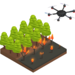
Fire/Smoke Detection
elipptic drones are equipped with specific sensors and technologies to detect smoke or fire. The method we use is through the use of thermal imaging cameras mounted on our drones. These cameras can detect the infrared radiation emitted from a fire’s heat source, allowing them to identify and track the source of the fire. Thermal imaging cameras can measure temperature variations and visually represent heat patterns. It enables the drone operator to identify the hottest areas, indicating the presence of a fire. The camera’s sensitivity to temperature changes allows it to quickly locate and track the spread of the fire, even in low visibility conditions such as heavy smoke.
 Benefits
Thermal imaging makes effective tools for smoke and fire detection. It provides a quick and efficient way to assess a fire’s size, location, and intensity, enabling faster response and potentially preventing further damage.
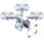
Telco Equipment Object Detection
elipptic drones are equipped with various sensors and imaging technologies to detect and identify telecom equipment at towers, such as antennas, microwaves, radio units and so on. Our machine learning algorithm and its visual inspection effectively work with high-resolution cameras that can capture images or video footage of telecom towers. These images are processed through elippticEngine to analyse and identify different types of telecom equipment.
 Benefits
The collected data can be used in the telecommunications industry for inspection, maintenance, or monitoring purposes.
Customised Object Detection
3Cell can train any model when the required data set is provided from various sources. Our pre-trained data sets also would be helpful in training further with additional inputs.